Sh Naveen Kumar Kushwaha
Introduction
India’s vast Himalayan borders, where the Indian Armed Forces stand guard, are constantly challenged by extreme weather conditions and the serious, unpredictable threat of avalanches. These snow-covered, high-altitude regions demand a state-of-the-art, reliable alert system to protect personnel, assets, and critical establishments. In a powerful stride towards the nation’s ‘Aatmanirbhar Bharat’ vision, DRDO’s Defence Electronics Applications Laboratory (DEAL), in association with the Defence Geoinformatics Research Establishment (DGRE), has developed such a solution, the Navigation, Avalanche warning & Tracking via Satellite (NATSAT) system. This indigenous, satellite-based warning-dissemination platform provides timely, critical alerts and navigational support, particularly when conventional communication systems fail. By leveraging advanced SATCOM technology, NATSAT is more than a warning system; it is a strategic facilitator that ensures the enhanced safety and operational effectiveness of Indian forces in the most hostile, snow-covered landscapes.
The genesis of NATSAT lies in a long-standing operational need to ensure uninterrupted situational awareness and effective communication in areas where conventional networks fail under climatic extremes. The solution demanded not just robust engineering but innovation that would combine meteorological data, satellite navigation, and real-time communication in one compact, autonomous system. DEAL and DGRE’s combined scientific expertise and field experience have rendered this possible. Through a system of automated weather stations, satellite-linked mini-terminals, and handheld units, NATSAT creates an integrated ecosystem that closes the loop between natural hazard prediction and swift field action.
In addition, NATSAT reaffirms India’s increasing capability in indigenous satellite communications and defence-level electronics. It symbolizes the convergence of India’s scientific innovation and strategic vision, converting the adversities of the landscape into opportunities for technological leadership. By providing 24×7 data transmission, weather forecasting, and alert dissemination, NATSAT not only saves lives but also enhances mission effectiveness. By doing so, it enhances India’s readiness to face climate-related issues in defence areas and serves as a template for its future applications in civilian disaster management and remote area connectivity.
NATSAT: Navigation, Avalanche warning & Tracking via Satellite
NATSAT is a state-of-the-art satellite-based avalanche and weather warning dissemination system developed indigenously by DEAL, DRDO, for the Indian Armed Forces. It is specifically designed to provide timely alerts and warnings to armed forces personnel deployed in snow-covered border areas of the country, where conventional systems often fail to provide timely alerts and warnings. The figure below shows the broad deployment scenario of the NATSAT System.
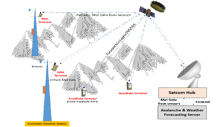
Here are its key components and features of the system:
1. NATSAT-Mini Terminal
NATSAT-Mini (NATSAT-M) Terminal is a SATCOM Terminal capable of interfacing with the Data Logger. A data logger is a device that integrates multiple environmental data sensors to collect information from them. NATSAT-M, along with the data logger and sensors, is mounted on an Automatic Weather Station Tower located in a snow-bound/avalanche-prone area. Data logger digitizes and formats sensor information (metrological sensors) suitable for sending over a low-bandwidth link. NATSAT-M receives formatted metrological data hourly from the data logger and sends it over the SATCOM link to the SATCOM hub. Hub sends this data to a central forecasting server via a leased line.
| Salient Features | Actual Image |
| Integrated with sensors to collect Met data | |
| Periodic Sensor Data transmission | |
| User Rate:1.2 Kbps | |
| IRNSS (NAVIC) + GPS | |
| Weight: ≤ 700 gms | |
| Temp: -40°C to +55°C | |
| Bi-directional communication |
2. SATCOM Hub with Integrated NMS & GIS
This is a central hub, like the heart of the whole solution. This Hub receives data from various Mini Terminals over the satcom link and sends it to the forecasting server. This hub is also responsible for managing satellite resources and disseminating Avalanche & Weather Forecasts to all handheld systems via an indigenously developed Network Management System and a GIS System.
3. Avalanche & Weather Forecasting Server
Forecasting Server utilizes meteorological data collected from NATSAT-M terminals along with other historical data as input to generate avalanche and weather forecasts. These forecasts are sent to the SATCOM hub on an over-leased line link.
4. NATSAT-Handheld Terminal
The NATSAT-Handheld (NATSAT-H) terminal is a two-way satellite communication terminal with built-in GPS and IRNSS capabilities. It is primarily used to distribute weather and avalanche forecasts to end users. It is also capable of sending a distress alert to the Hub in case of an emergency. The user may also log the manual weather parameters like temperature, wind pressure, etc., into the Server. NATSAT-H features a 4.3-inch touch screen LCD for user input and information display. The end user carrying this unit will be able to receive a daily weather forecast and an avalanche alert for the region. The terminal will also display an alert notification if a person carrying it enters the avalanche zone. This terminal also features an offline navigation application to assist with navigation in areas where roads are covered by snowfall. This terminal could be a lifesaver thanks to SOS, offline navigation, and live location sharing.
| Salient Features | Actual Image |
| Avalanche & weather alerts | |
| SOS, SMS, Offline navigation | |
| Periodic Location Reporting | |
| 4.3” Resistive TFT | |
| User Rate:1.2 Kbps | |
| IRNSS (NAVIC) + GPS | |
| Weight: ≤ 800 gms | |
| Temp: -20°C to +55°C | |
| Bi-directional communication |
The development of the NATSAT system represents a significant step towards India’s goal of achieving self-reliance in defense technologies, in line with the national vision of ‘Aatmanirbhar Bharat’. These systems are not only vital for enhancing the operational effectiveness of the Indian Armed Forces but also for reducing the country’s dependence on foreign communication technologies, thereby strengthening national security. By providing secure, reliable, and high-capacity communication solutions, NATSAT ensures that the Indian military can perform its operations across vast and challenging operational environments with added safety. This is particularly crucial in strategic defense scenarios, whether in conventional warfare, where quick, safe passage to defense forces is essential for tactical coordination, or in humanitarian assistance and disaster relief operations.
In essence, this system empowers the Indian Armed Forces with cutting-edge technology to ensure strategic advantage across a wide range of military and non-military operations. By reducing reliance on foreign systems, they enhance national sovereignty and provide India with the autonomy to protect and secure its borders, while also supporting critical missions during peacekeeping and disaster relief.
Conclusion
The DEAL-developed NATSAT is a monumental achievement for India’s defence technology landscape. It unequivocally addresses a vital, life-threatening problem in the lives of the Indian Armed Forces stationed on the snow-covered borders, ensuring safer mobility and timely intelligence. Far from a technological wonder, NATSAT reflects the essence of strategic autonomy, considerably reducing dependence on foreign technology and enhancing national security. As a pillar of India’s modernization initiative, this homegrown SATCOM-derived platform keeps the Indian armed forces extremely flexible and operationally responsive across a range of scenarios, from conventional and hybrid warfare to critical disaster response efforts, firmly establishing NATSAT as the leading defence preparedness specialist.
Apart from its operational significance, NATSAT also demonstrates the triumph of India’s collaborative R&D ecosystem, where domain-specific laboratories within DRDO come together to address intricately complex national issues. DEAL’s satellite communications expertise and DGRE’s control of terrain and avalanche science have led to a complete system that harmoniously integrates data collection, analysis, and real-time field communication. This achievement speaks to the nation’s capability to design, develop, and deploy mission-critical and human-focused technologies, safeguarding lives while advancing strategic interests.
Importantly, this technological success has translated into meaningful industry participation and accelerated indigenisation. DRDO handed over 12 Licensing Agreements for Transfer of Technology (LATOTs) in October 2025. In a significant step towards operational deployment, DEAL transferred the NATSAT-Handheld and NATSAT-Mini Terminals to Bharat Electronics Limited, Panchkula, further strengthening the bridge between laboratory innovation and battlefield readiness.
Looking to the future, NATSAT’s architecture provides the building block for yet more defence geoinformatics and climate resilience breakthroughs. With even greater scalability, it can be further leveraged to support civilian infrastructure in high-risk zones, mountain rescue operations, and cross-border humanitarian efforts. Essentially, NATSAT is more than a product; it is a paradigm shift in India’s defence communications framework. It represents a confident leap towards technological independence, where science and strategy converge to keep every soldier, regardless of terrain or temperature, connected, informed, and secure under the national flag.
The author, Sh Naveen Kumar Kushwaha, is a Scientist ‘E’ with DEAL, DRDO.
A note of thanks to Sh Manoj Kumar Dhakha, OS & Director, DEAL, DRDO, for useful inputs, comments and suggestions.
