
Dr Shagun Aggarwal

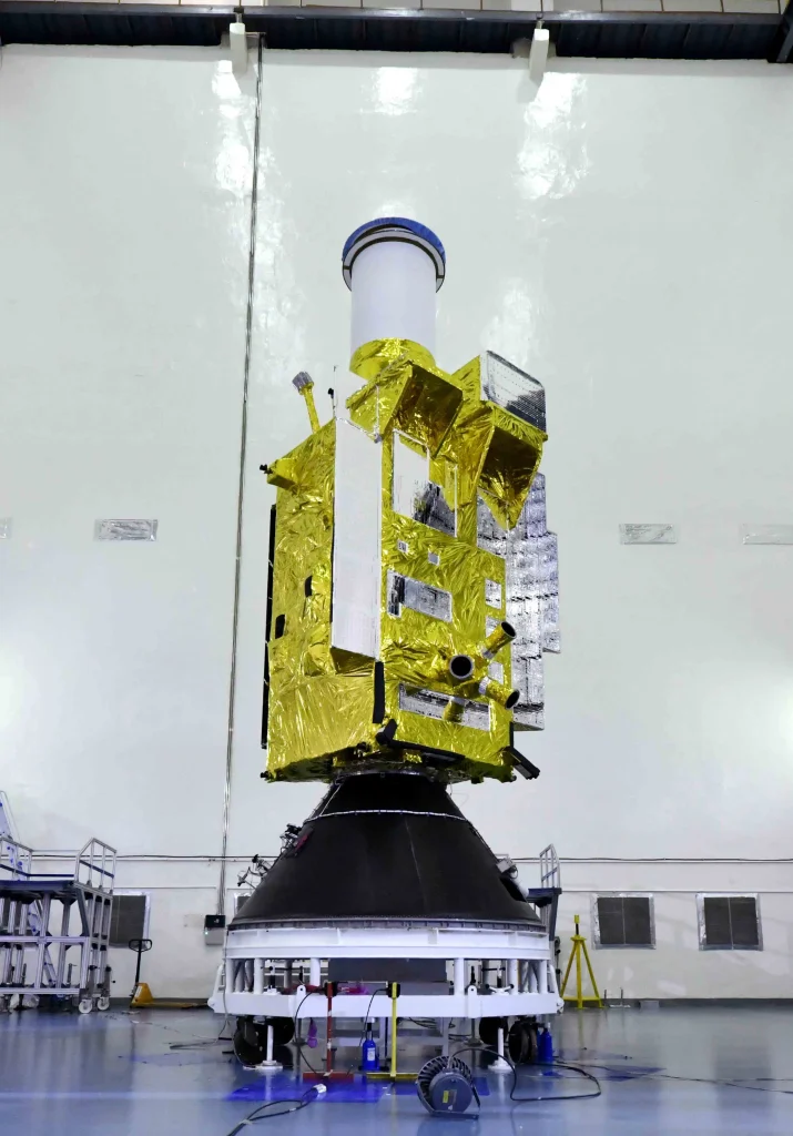
The launch of the EOS-05 mission marked another milestone for the Indian Space Research Organisation (ISRO) as its first imaging satellite designed to operate from geosynchronous orbit. Powered by a cryogenic upper stage, the GSLV-F17 launched EOS-05 on 4 September 2026 from the Satish Dhawan Space Centre, initially injecting it into a Sub-Geosynchronous Transfer Orbit. The spacecraft then used its Liquid Apogee Motor (LAM) to progressively raise its orbit. After three manoeuvres, ISRO reported an orbit of approximately 34,903 × 35,884 km, placing the spacecraft toward its intended geosynchronous orbital position at 85.5°E. The EOS-05 spacecraft is a 2,367 kg geostationary Earth observation satellite built on ISRO’s I-2K (I-2000) bus platform with a 9-year operational life. Its payload consists of multi-band and hyperspectral imaging sensors, including a 42-metre resolution multispectral VNIR sensor, a 158-channel hyperspectral VNIR sensor, a 256-channel hyperspectral SWIR sensor, and a thermal multispectral LWIR sensor. Operating from its geosynchronous slot, the spacecraft is designed to deliver rapid imaging capabilities, scanning the entire Indian mainland every 30 minutes or revisiting specific disaster areas every 5 to 10 minutes. ISRO describes it as a state-of-the-art Earth-observation spacecraft, and has identified the mission for greater strategic use.
India is trying to expand its domestic space industry and build an indigenous Earth-observation ecosystem. EOS-05 deserves to be viewed not simply as a satellite launch, but as part of a much larger transition in India’s space programme. India’s Earth-observation programme is no longer based around a single type of satellite or sensor. Optical imaging, synthetic aperture radar, multispectral observations, navigation, communications and increasingly sophisticated data-processing capabilities are becoming parts of a much broader space-based information system. EOS-05 mission adds another addition to that architecture: imaging from geosynchronous orbit.

While low Earth orbit benefits Earth observation because the spacecraft operates a few hundred kilometres above Earth’s surface, geosynchronous orbit offers a fundamentally different geometry. A LEO satellite is continuously moving relative to the surface. It sees a particular location for a limited period before moving on, and another satellite or another orbital pass is required to observe the region again. An imaging spacecraft can observe a very large portion of Earth and maintain a much more persistent view of a particular region from a geosynchronous orbit. That creates opportunities for applications where how frequently something can be observed may be as important as how finely it can be resolved. Rapidly evolving weather systems, large-scale environmental changes, disasters and strategically important areas can benefit from frequent observation.
There is another reason this evolution matters. Earth-observation data can form an important component of an ISR architecture. Dependence on foreign Earth-observation data can limit availability, tasking, data policy, and continuity. Developing domestic spacecraft and launch capabilities gives a country greater control over what it observes, how often it observes it and how the resulting data are processed and distributed. As a satellite collects observations, those observations become data, which is then processed into information. Information can then contribute to situational awareness and, where relevant, intelligence. A modern ISR architecture can combine optical imagery, radar, communications, navigation, signals intelligence, ground-based systems and other sources. This makes India’s growing EO capability strategically significant.
The aspect of EOS-05 that deserves greater attention is the technological ecosystem required to make such a mission possible. A sophisticated satellite like EOS-05 is not the product of a single technology. It requires spacecraft engineering, payload development, attitude control, power systems, thermal management, communications, propulsion, ground infrastructure, mission operations and data processing. EOS-05 also required GSLV-F17 to place the spacecraft into a Sub-GTO, followed by autonomous spacecraft manoeuvres to raise the orbit. The successful sequence demonstrates capabilities across both launch-vehicle and spacecraft operations. The mission tells a broader story about India’s ability to develop and operate complex space systems. And this is happening alongside an important change in India’s space-sector structure. India’s ambition is moving beyond:
“Can India build an Earth-observation satellite?”
towards:
“Can India build a complete Earth-observation ecosystem?”
Which includes satellites, payloads, launch services, ground infrastructure, analytics, applications and commercial data services. The next phase of India’s space-based observation capability will not be defined simply by launching increasingly sophisticated satellites. The greater opportunity lies in integration.
The real value of an expanding satellite fleet will emerge when observations from different platforms, sensors and orbital regimes can work together. Optical and SAR imagery could be fused to provide a more complete picture of an area; observations from LEO and GEO could add both spatial detail and temporal continuity; and AI-driven analytics could identify significant changes across vast volumes of data far faster than human analysts could do alone. At the same time, integrating government and commercial datasets and building the ground infrastructure needed to process this growing flow of information will become increasingly important. Ultimately, the question is how quickly and effectively that data can be transformed into actionable information. The EOS-05 mission adds a new orbital perspective to India’s Earth-observation architecture, complementing existing LEO optical and radar capabilities while demonstrating advances in spacecraft operations, propulsion, launch systems and mission management. More importantly, it comes as India’s space sector evolves from an overwhelmingly ISRO-led model toward a broader ecosystem involving private companies, start-ups, research institutions, and new commercial Earth-observation constellations.
The long-term significance of EOS-05, therefore, will not be determined by the satellite alone. It will depend on what India builds around it — how effectively its observations are combined with those from other satellites, how rapidly they can be processed, and how successfully indigenous industry can turn these capabilities into a resilient and scalable national space infrastructure. If GEO imaging, LEO optical and SAR systems, hyperspectral sensing, navigation, communications, ground infrastructure and AI-driven analytics increasingly operate as parts of a connected architecture, India’s space programme will be moving beyond individual missions towards something much more consequential: a persistent, multi-sensor and sovereign capability to observe and understand the Earth.
Dr. Shagun Aggarwal is a space researcher specializing in space debris mitigation, with applications in spacecraft deorbiting and orbital sustainability. Her work combines experimental plasma research, geospatial analytics, and space systems design to address challenges in low Earth orbit operations.