
By Vaibhav Agrawal
India is focusing on enhancing its space capabilities and emphasising the small satellite (SmSats) sector to address performance limitations and meet the crucial Command, Control, Computers, Communications, and Intelligence, Surveillance and Reconnaissance (C4ISR) needs necessary for military operations. High-altitude platforms (HAPS) are a cost-effective and versatile solution that can offer extended, high-resolution coverage of specific areas, making them essential in bolstering defence communication infrastructure, both territorial and space-based. This would enable the provision of robust, round-the-clock surveillance on the borders and in the Indian Ocean region (IOR).
Previously, it was reported that Hindustan Aeronautics Limited (HAL) and the startup NewSpace Research and Technologies Private Limited (NRT) have joined forces to commence development on an enormous solar-powered unmanned aircraft which is capable of remaining airborne in the stratosphere for several months. The High Altitude Pseudo-Satellite Unmanned Aerial Vehicle (UAV), with a span of over 50 meters, is part of a new category of solar-powered platforms being designed across the globe for continuous surveillance, specialised science missions, and communication purposes. Named ‘CATS-Infinity’, this aerial vehicle will be created under a joint development partnership model between the two organisations and will represent India’s initial venture into the mostly untapped stratosphere for both military and civilian applications.
Compared to ground-based communication networks, HAPS can cover larger areas with less interference, making them an attractive option. Additionally, they can facilitate data transfer by acting as an intermediate link between satellites and ground-based telecom networks. Due to their lower transmission delay, HAPS can outperform satellites in some applications, such as telecommunication (TELECOM) and Earth observation. Furthermore, they can be revamped and reused with reconfigured payloads every few months. In a 2017 study that compared a constellation of Low Earth Orbit satellites and HAPS platforms for remote sensing, HAPS had “a clear advantage for revisiting a large zone with higher predictability and accuracy” because of their ability to remain continuously over an area for long periods.
India’s lengthy and complex land border of about 15,106.7 km, and a coastline of 7,516.6 km make border security a critical concern, necessitating diverse solutions. Positioned at the edge of the Earth’s atmosphere, HAPS can contribute to efficient border patrolling by tracking movements deep into enemy territory or over the open seas with their focused attention on a specific area. With high-definition optical and infrared cameras and state-of-the-art sensors, these aerial platforms are well-suited for round-the-clock missions, border patrolling, target tracking, maritime surveillance and navigation, and even missile detection. A network of HAPS can supplement the gaps in satellite services.
When combined with a platform like the domestically produced CATS, HAPS would play a pivotal role in supporting coordinated attack missions by offering communication to troops operating in remote areas and providing Battle Damage Assessment (BDA) through live video feeds and images. During the Balakot air strikes, the absence of such information raised doubts about the mission’s effectiveness, making it critical to have it available in real-time to determine its success and plan the next steps.
HAPS In Maritime Surveillance
Earlier, in an event organised by Indian Space Association (ISpA), Vice Admiral G Ashok Kumar (r), National Maritime Security Coordinator, addressed the startups on the challenges faced by the Indian Navy in the space domain and what they are looking at. He said, “the problem that I am trying to highlight is the problem of identification, the issue of surveillance and the problem of domain awareness. These are the things which are critical for any maritime operations. Take the Navy’s case in 2013, the GSAT 7. Since then, the Navy’s backbone for the networks and co-operations has been those particular satellites.”
It was revealed that the Navy is looking at a large footprint and information security as these are critical for maritime operations. The Navy already uses naval maritime advancements in aircraft to carry out maritime surveillance operations, but the area is too vast; the number of aircraft which will be required will be humongous. The audience learned that the simplest way is to go to the satellite advances in such a situation.
Most nations have promulgated future orders, which have made it compulsory for vessels more than 20 metres in length to have a transponder; these are again picked up by the satellites. So any fishing vessel which is more than 20 metres in length and out in the sea is actually picked up by them. Very interestingly, out of the three lakh fishing boats India has, about 2,40,000 are less than 20 metres, so the Navy has yet to learn where they are.
The HAPS can detect vessels, cue other assets such as planes or helicopters to perform identification or rescue operations and discriminate between standard commercial traffic and migrant vessels using an AIS receiver alongside the radar payload. The HAPS can also act as a VHF relay, providing an over-the-horizon voice channel to vessels within its 580km radio horizon.
By employing imaging radars with synthetic-aperture radar (SAR) or inverse synthetic-aperture radar (ISAR), the HAPS can enhance identification capabilities and decrease reliance on other sensors. Overall, HAPS could significantly improve maritime surveillance and facilitate a more effective response to migration flows.
HAPS For Communications
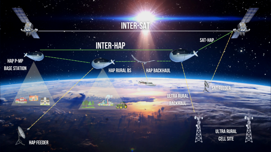
Using just a few HAPS, it is possible to establish a communication network covering an entire country, with each HAPS serving as a 20km high mobile phone tower and providing excellent coverage within a 200km range. While this approach may not be competitive in regions with high subscriber density, it offers a quick and easy way to provide coverage for sparsely populated regions. Compared to satellite communications, HAPS offers several advantages, including lower latency and a much better link budget. Since they are 200 times closer than geostationary satellites, user terminals need 400,000 times less power to communicate with them, enabling phone-like terminals with omnidirectional antennas that can work on the move. As a result, such a HAPS network would be a formidable competitor to low Earth orbit (LEO) satellite networks like Iridium.
Apart from civilian applications, HAPS also has military applications. A communication network with long-range and small user terminals is beneficial for ground forces operating far from their bases. In conflicts such as the war against the Islamic State (ISIS) in Syria, deploying a few HAPS in international waters and neighbouring countries would provide long-range communications to troops operating inside the country. Moreover, the same HAPS could be equipped with signal intelligence payloads with the same range as the communication payloads. In that case, they could detect emitters and listen in on mobile communications over most of the country.

Ground Surveillance Measures
To remain within the security domain, HAPS can offer persistent ground surveillance, either 24/7 with radar or during clear weather conditions using optical sensors. Radars have a noteworthy feature for wide-area surveillance: utilising the Doppler effect, they can easily distinguish moving targets from static terrain and objects, enabling the detection of moving vehicles within a radius of 70km in Ground Moving Target Indicator (GMTI) mode. This surpasses the range of optical sensors, which are restricted by atmospheric conditions and can only detect targets up to 20 km at a 45° off-vertical angle or 35 km at a more aggressive 60° off-vertical angle.
Nonetheless, optical sensors still have their uses, particularly over urban areas. HAPS move slower than typical surveillance drones and therefore require pre-positioning. In urban settings, buildings obstruct the view of streets, necessitating a closer-to-vertical look angle than in rural areas. The taller the building, the more obstructions there will be.
Aids In SIGINT
A HAPS provides a platform for various types of surveillance equipment, including signal intelligence (SIGINT) receivers and radars, as illustrated in the aforementioned examples. SIGINT receivers have a significant advantage over radars as they are passive and require only signals for a one-way trip, making them more energy efficient and capable of longer ranges. A HAPS positioned off the coast of Syria could employ optical sensors to monitor a specific port while the radar watches over coastal areas and up to 400km over the sea. Though the line of sight obstruction may limit communication and high-frequency SIGINT ranges to 200km over land based on Airbus’ conservative 5° incidence angle criteria to ensure all subscribers of a communication service can be reached at all times, the actual lines of sight computation reveal coverage that extends far beyond this distance.
The above examples illustrate the versatility of HAPS as a platform for a wide range of surveillance payloads, including SIGINT receivers and radars. One significant advantage of passive SIGINT receivers is their ability to operate with lower power consumption and longer ranges than radars.
For emitters located on vantage points like radars or cell phone towers or for shipborne emitters, the relevant range is the theoretical radio horizon, which is 580km. For flying targets, such as jets in transit, the radio horizon is even further away, at 810km for targets flying at 3,000m and 1,000km for targets flying at 10,000m. The SIGINT system can cue narrow field-of-view sensors, such as a radar in tracking mode.
Overall, HAPS are an excellent platform for SIGINT, particularly dirigible HAPS, which are less sensitive to payload volume and can accommodate more or larger antennas. However, the main limitation to this use may be that some countries may object to a listening post located on the edge of their territorial waters, potentially leading to diplomatic or other consequences.
The aforementioned surveillance operations generate copious amounts of data, which can be downloaded directly in the theatre within the communication range of the HAPS and processed there. If the data needs to be transmitted further, the HAPS can facilitate this directly through a laser link to a geostationary satellite or a more conventional radio satellite connection. The HAPS can even function as its own backhaul communication link. From its 20 km altitude, the radio horizon extends up to 580 km away (or 500 km for optical horizons), allowing for a “hop” from one HAPS to another that can be up to 1160 km (or 1000 km for optical) in length.
This implies that only three hops and as many HAPS (in addition to the data-collecting one) are needed to traverse the Mediterranean, for example. Depending on the cost of HAPS relays and the distance to be covered, using HAPS for backhaul may be less expensive than utilising satellite communications. Additionally, it can be redeployed as needed and provides a sovereign solution that can be hardened against interference and interceptions because the links between the HAPS can be highly directional.
Efficiency Across The Spectrum
HAPS have a wide range of surveillance payloads, including electro-optical/infra-red (EO/IR) solutions, SAR with GMTI function, communication payloads like range extenders, 4/5G/WiFi networks, backhaul data carriage, electronic intelligence (ELINT) and electronic warfare (EW). The current technology limitations of HAPS intelligence, surveillance and reconnaissance (ISR) payloads allow observations of up to 80-100 km from stratospheric altitudes, which is two to three times more than that offered by medium altitude, long endurance (MALE) UAVs. The Indian Armed Forces will benefit from this previously unknown ISR capability provided by HAPS, which was critically exposed during the Doklam crisis, the Balakot airstrikes, and the ongoing crisis in eastern Ladakh. The Indian Navy, with its vast boundary to manage across the Indian Ocean region (IOR), will be an immediate beneficiary. When embedded with Indian MALE UAVs and reconnaissance satellites, HAPS will help close the enormous gap in the demand and supply of ISR data.
While HAPS offers endless possibilities for military applications, its civilian applications will benefit India more in the coming decades. Advanced use cases for a persistent eye in the sky include smart city management, natural disaster management, a logistics node and highway management, among others. Imagine how a swarm of HAPS persistently operating over disaster-prone areas in India could provide real-time pre-warning of a natural disaster unfolding, enabling a much faster response and saving countless lives and property loss.
One of the most disruptive applications for HAPS in the future will involve providing telecommunication connectivity through beaming down networks from the sky. HAPS will be able to offer connectivity all over India, particularly in areas where terrestrial networks are patchy due to terrain and cost constraints. While the world is witnessing a transition of internet connectivity to LEO satellite-based constellations such as OneWeb and Starlink, HAPS can perform the same task with significantly lower capital investment, faster connectivity, and higher data rates due to lower latency.
One such initiative is Softbank’s ‘HAPS Mobile,’ which is currently conducting trials to deliver 5G internet from the skies over Japan. A critical challenge for any HAPS vehicle is the ability to operate for 365 days, even on the winter solstice in northern latitudes, which requires maximising the wing span to its structural limits. To achieve this, aerospace engineers must develop a highly flexible and ultra-lightweight airframe capable of accommodating solar panels, batteries, payloads, and other subsystems.
To summarise, pseudo-high-altitude satellites offer cost-effective and localised persistent surveillance over land and sea. While HAPS, with only optical payloads, are limited in mobility, larger models with advanced multifunction radars have a much larger field of view, making them useful for coastguard applications. HAPS also excel as a signal intelligence platform for long-range and long-term collection. However, their first application is likely to be providing communication in sparsely populated areas, with Earth observation as a secondary use. In some niche cases, HAPS may even become a serious competitor to observation satellites.
